

April is drawing to a close. The month was 2.5° warmer than normal and 0.72” drier than normal in the Hartford area. That mid-month stretch of record warmth was a nice highlight.
After today’s rain, conditions improve on Friday. Sunshine will mix with clouds in the afternoon, and temperatures will climb into the 60°–65° range for most.
The weekend forecast, unfortunately, remains a bit challenging. A weak disturbance rotating beneath a large upper-level low anchored over Quebec will be enough to bring clouds and a few showers on Saturday. Rainfall totals should be fairly low—generally 0.1” or less.

Another disturbance (we call these shortwaves) right behind the first one will be enough for a coastal storm to develop off the Mid-Atlantic.
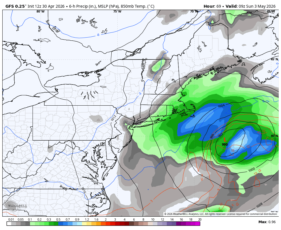
This system should pass fairly far south and east of Connecticut, but it may be close enough to bring a period of rain Saturday night. Thankfully, it should move out around daybreak Sunday.
One bit of good news: there appears to be a window for warming early next week. As a Bermuda High sets up offshore, it should help pump warmer air into the region. 850mb temperature anomalies of more than +5°C should support a brief surge of warmth. Tuesday, in particular, looks delightful, with highs around 75° inland.
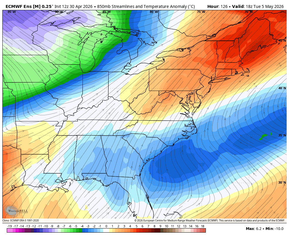
Don’t get used to it. The pattern remains unsettled and, on balance, continues to favor cooler-than-normal conditions. A strong cold front will approach from the west, with rain expected Wednesday into Thursday. Currently, most guidance shows 0.5”–1.0” of rain midweek, but as seen in the Euro Ensemble, 16 of 50 members produce more than 1.0” of rain in the Hartford area.

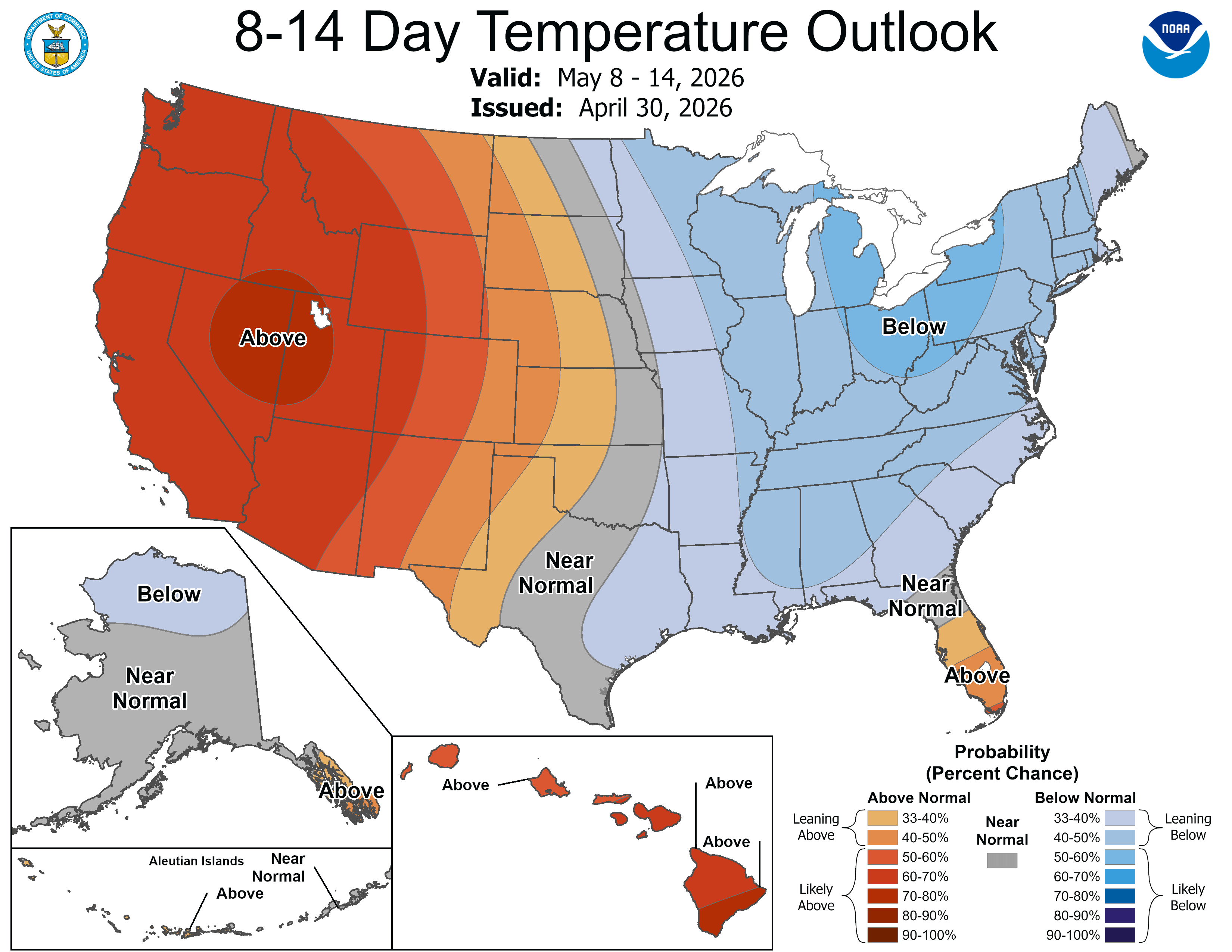
There will be additional chances for rain later in the week, and the CPC 8–14 day temperature and precipitation outlook continues to signal an unsettled pattern through mid-month.

Here is your Daily Weather Almanac for Friday, May 01, 2026
🏙️ Hartford Area 30 Year Normals
- Normal High: 67°F
- Normal Low: 44°F
🏛️ Hartford Area (BDL) Records
- Record High (max temp): 88°F (2001)
- Record Low (min temp): 28°F (2008) ⚠️ (monthly record)
- Record Highest Minimum: 58°F (1983)
- Record Lowest Maximum: 44°F (1909)
- Record Precipitation: 1.50 in (1976)
- Record Snowfall: 0.0 in (2025)
- Max Snow Depth: 0 in (2025) ⚠️ (monthly record)
🏖️ Bridgeport Area (BDR) Records
- Record High (max temp): 83°F (1957)
- Record Low (min temp): 36°F (2008)
- Record Highest Minimum: 54°F (1985)
- Record Lowest Maximum: 49°F (1962) (tie — also in 1950)
- Record Precipitation: 1.49 in (2014)
- Record Snowfall: 0.0 in (2025) ⚠️ (monthly record)
- Max Snow Depth: 0 in (2025) ⚠️ (monthly record)
🌅 Sunrise & Sunset
- Sunrise: 05:47
- Sunset: 19:49
🌙 Moon Phase
----------------------------------------
- Next Moon Phase: Full Moon on Fri May 01, 2026
📅 Calendar
----------------------------------------
- Next 3 Holidays:
- Mother's Day on Sun May 10 (in 9 days)
- Memorial Day on Mon May 25 (in 24 days)
- Juneteenth National Independence Day on Fri Jun 19 (in 49 days)
🌊 New Haven High Tides
- 11:55 AM EDT • 6.15 ft
🌊 Old Saybrook High Tides
- 11:11 AM EDT • 3.23 ft
- 11:20 PM EDT • 4.30 ft
🌊 New London High Tides
- 10:00 AM EDT • 2.38 ft
- 10:09 PM EDT • 3.16 ft