
Incredible 103 m.p.h. Wind Gust
Powerful Nocturnal Thunderstorm on the Connecticut Shoreline

It was unwarned, but it shouldn’t have been.
A powerful thunderstorm swept across the Connecticut shoreline overnight, producing a narrow but destructive swath of wind damage from Milford through New Haven and into East Haven.
There are really two separate forecast questions worth looking at with this storm: Was the potential for severe weather predictable several hours in advance? And once the storm developed, was there enough evidence on radar to warrant a warning?
The environment was supportive of strong to severe thunderstorms. We mentioned the potential for strong thunderstorms during the evening newscast prior to the event, but there was no outlooked area in Connecticut from the Storm Prediction Center.
Most convection-allowing models showed a cluster of thunderstorms moving through Connecticut shortly after midnight.
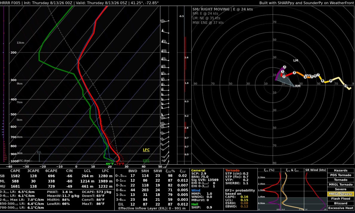
Here’s a 5-hour HRRR forecast sounding valid at 1 a.m. Thursday for New Haven.
There’s an appreciable, though certainly not extreme, amount of CAPE. 1,681 J/kg of MUCAPE is forecast. Low-level lapse rates are relatively steep as well.
The actual observation at Tweed-New Haven Airport at 1 a.m. was 77°/67°, which would imply even steeper low-level lapse rates than the HRRR forecast and, importantly, not much of a low-level inversion.
More important than any individual parameter may have been what wasn’t present: a strongly stable nocturnal boundary layer. The water temperature in New Haven Harbor was around 76°, virtually the same as the air temperature at Tweed. There wasn’t much opportunity for a stabilizing marine layer to develop ahead of the storm.
In other words, this wasn’t a case of a surface-based thunderstorm encountering a cool, stable marine layer along the Connecticut shoreline. The boundary layer remained quite warm and relatively well mixed for 1 a.m.
Another notable feature on the forecast sounding is the 44 knots of 0–6 km bulk shear. That’s more than enough shear to organize thunderstorms when coupled with sufficient instability.
So while the environment wasn’t screaming a widespread severe weather event, the ingredients were there for an organized thunderstorm capable of producing damaging winds.
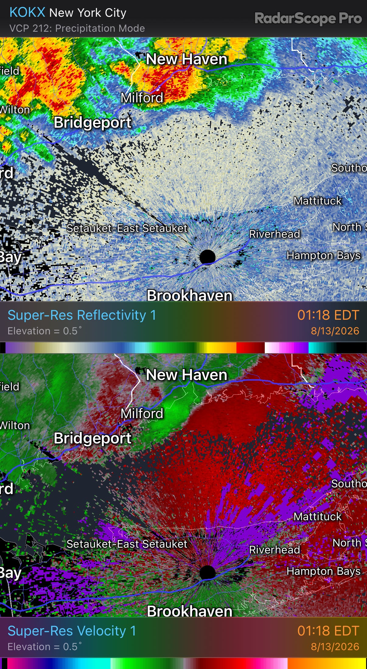
At first glance, the storm isn’t particularly impressive as it crosses New Haven Harbor.
The storm motion is generally west to east and the storm does not initially have the appearance of a strongly outflow-dominant thunderstorm which so many thunderstorms near the Connecticut shoreline are.
Look a little more closely at the velocity data, however, and things become more alarming.
There are inbound radial velocity values of around 39 knots just offshore of Milford.
39 knots doesn’t leap off the velocity display as an extreme value. But in this case, simply looking at the magnitude of the radial velocity is misleading.
That’s because most of the wind in this storm is blowing nearly perpendicular to the radar beam originating from KOKX on Long Island.
Doppler radar only measures the component of the wind moving toward or away from the radar. When the wind is blowing nearly perpendicular to the radar beam, the radial velocity can dramatically underestimate the actual wind speed.
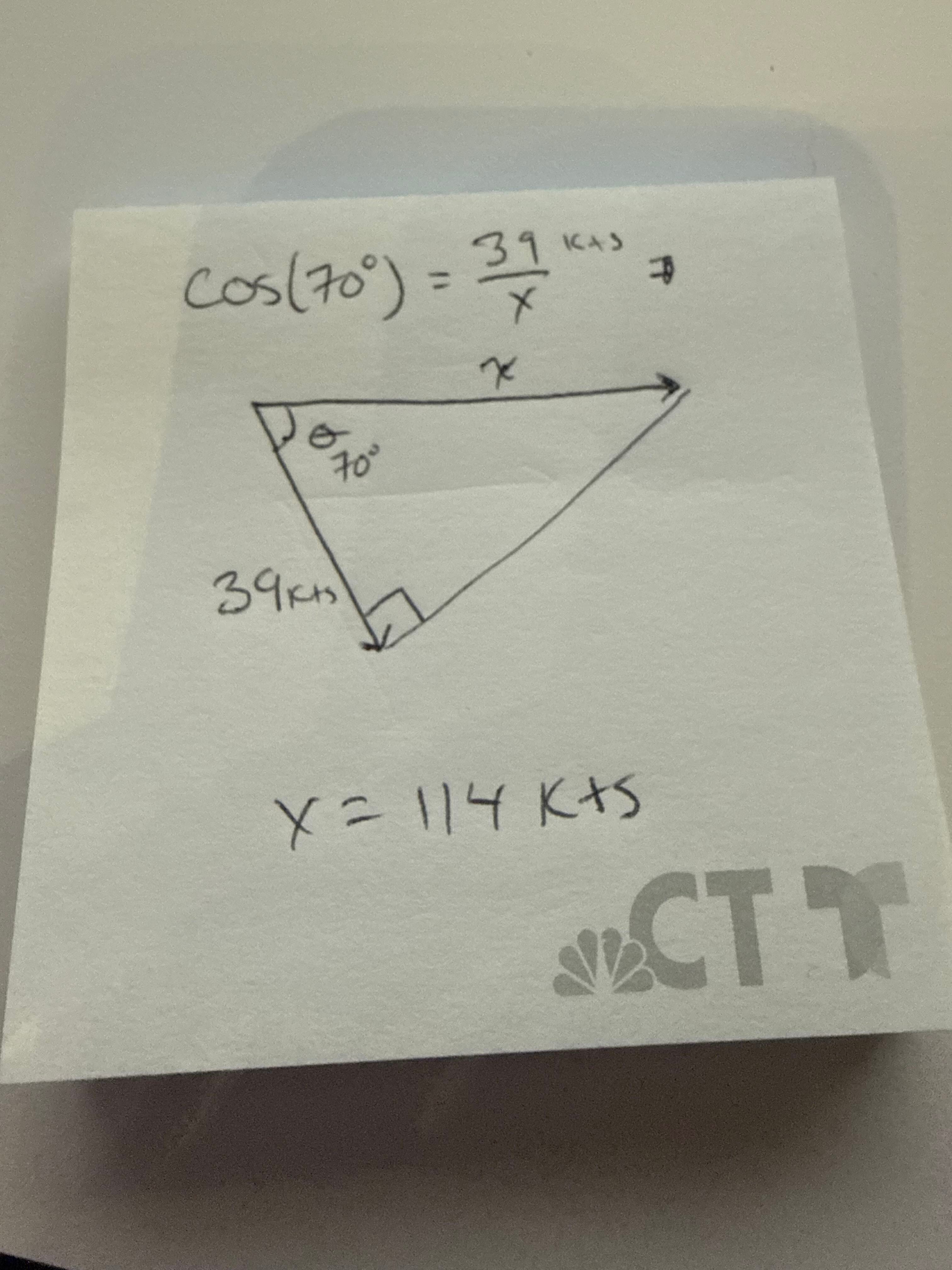
Time for a back-of-the-envelope, or more precisely, back-of-a-little-sticky-note, velocity calculation.
The relationship between radial velocity and the actual wind velocity can be approximated by:
Vr = V cos θ
where Vr is the radial velocity measured by the radar, V is the actual velocity and θ is the angle between the wind vector and the radar beam.
If we assume the wind was blowing about 70 degrees off the KOKX radial, just an eyeballed estimate, then:
V = 39 kt / cos(70°)
That gives an actual velocity of roughly 114 knots.
Now, this calculation comes with an enormous caveat.
As the wind direction approaches 90 degrees relative to the radar beam, small errors in the estimated angle produce very large changes in the calculated velocity. At 65 degrees, for example, 39 knots radial corresponds to about 92 knots. At 70 degrees it’s about 114 knots. At 75 degrees it’s more than 150 knots.
What it does show is that 39 knots of radial velocity significantly understated the magnitude of the actual wind because of the unfavorable radar geometry.
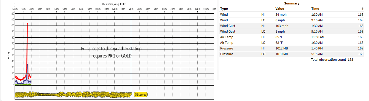
We have a report from a WeatherFlow station at Lighthouse Point Park of a wind gust to 103 mph.
A nearby personal weather station recorded a gust to 97 mph in Morgan Point (East Haven) and a third station had a wind gust to 86 mph close by.
The westerly wind also had an unusually favorable exposure at Lighthouse Point. It blew across New Haven Harbor before reaching the park, encountering relatively little surface friction along the way.
The damage at Lighthouse Point Park was substantial. Structural damage occurred at the historic carousel building and numerous large trees were uprooted across the park.

In Milford, trees were uprooted across town, with significant structural damage reported to one building near the Milford/Orange town line.

There is also a particularly cool view of the storm from the other side of Long Island Sound. A meteorologist on the North Shore of Long Island photographed the storm's shelf cloud as it moved north toward New Haven.

I wasn’t surprised that we had an isolated severe thunderstorm. I was surprised by this storm’s intensity.
These extreme convective wind gusts can be remarkably localized. Less than a mile away from some of the most significant damage, the peak wind gust at Tweed-New Haven Airport was only 37 mph.
I can’t think of many stronger wind gusts actually recorded in Connecticut. Sometimes it’s just a stroke of luck having an anemometer in the exact right place of an intense storm.
Meteorologically this storm is an interesting example of how an otherwise unremarkable-looking nocturnal thunderstorm can produce an exceptional localized winds. The environment was supportive, the storm was organized, and the radar contained clues that something significant was underway.
Thankfully, despite the destructive winds, no one was injured.